One of the most important resources humans have is water from irrigating crops, facilitating trade and defense capabilities, or simply purifying and consuming it. There’s no surprise to the benefits an open body of water can provide. Water occupies 72% of the planet, and nearly 40% of the world’s population lives within 100km of the coast (United Nations, 2017). Many have been able to cultivate a way of life simply through proximity to the coast. In America alone, the nation’s coastal counties produce more than $9.5 trillion in goods and services (NOAA, 2022). If that were a country, it would have the third largest GDP behind the United States and China. In rural areas within Southeastern Africa, many communities that live below the poverty line rely heavily on rain-fed agriculture and coastal resources to support their livelihoods (UNEP, 2022).
What we’ve seen in the last several decades is the drastically changing climate leading to cataclysmic natural events. The frequency of hurricanes, typhoons, and storms has increased, while global temperatures and sea levels are rising at a startling rate. And when it comes to agricultural practices, we’ve seen inconsistent weather patterns lead to shifting agroecosystem boundaries, invasive crops and pests, and more frequent extreme weather events and reduced crop yields (World Bank, 2021). Changing climate has proven to be life-threatening in many direct and indirect ways. As leading experts have outlined, global climate change is no longer a future problem (NASA, 2022).

While coastal cities will have to bear the brunt of it, the effects of the changing climate will be felt worldwide. What has proven to be such a beneficial way of life will ultimately have its cost, sooner rather than later. What we’ve seen in Southeastern Africa is that recurring natural hazards such as cyclones, floods, sea level rise/coastal erosion, and drought (Adaptation Funds, 2022), coupled with poor governance and inadequate infrastructure, have wreaked havoc on the way of life, further exacerbating the need for solutions.
In Africa, The solution came from an initiative backed by the Global Environment Facility, the U.N. Environment, and the Government of Madagascar, which has adopted a policy to build resilience in the coastal communities (UNEP, 2022). Specific actions are being undertaken that target restoring and protecting the shoreline and cultivating livelihoods that overcome climate susceptibility. It was essential to adopt ‘smart’ agricultural practices to overcome any climate-related limitations and diversify income strategies.
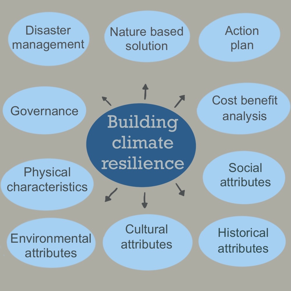
Natural defense against erosion is also a crucial factor of resilience within coastal areas. Project activities include the restoration of mangroves along the shore, which serve as coastal protection by providing a buffer for the shoreline. The mangroves also provide a habitat for wildlife and fisheries that are instrumental for livelihood and income. It is possible to enact adaptive measures, but to do so, local governments must identify key characteristics of their settlements and how they react to the adaptation choices. What this shows is that building climate resilience requires adaptive measures. The problem is that adaptation is complex when it comes to local decision-making. The decision-making process should entail several indicators that form the basis for adaptation planning for all coastal cities, regardless of size. Some of the potential indicators could include the following:
- Physical characteristics: These indicators and their identification are essential to determine whether cities are susceptible to imminent climate disasters. Knowledge of the physical characteristics also helps with responses in protection and retreat. The S. Army Corps of Engineers (USACE) found that two-thirds of the deaths during Hurricane Katrina were the result of levee and flood wall failure (ASCE). Topographical measures such as slope, angles, and distances near shores are excellent and necessary indicators, along with proximity to a hurricane/cyclone/typhoon area. Interior rainfall from flooding can occur from hurricanes or storms that produce large amounts of precipitation: This can also occur from rainfall along river basins located upstream from a settlement.
- Environmental, social, cultural, and historical characteristics: This information provides a framework of what measures are needed, the trade-offs, potential costs and benefits, and, more importantly, the locations of potential risk. These characteristics also indicate whether these are locations at high risk or culturally significant areas in need of preservation or locations on higher ground that can be used for safety.
- Governance: This entails all the measures that are related to complex decision-making. As Major & Juhola (2021) state, public, private, and civil society actors and institutions can influence and impart authority regarding urban climate planning and implementation processes. This will differ depending on municipality, locale, and agency. As we’ve seen with other urban planning measures, what works for one city won’t be ideal for others. And in the case of climate justice, although necessary, governance is a complex procedure, often marred in red tape. Still, it’s important to recognize issues specific to each area and mitigate those issues accordingly.

Once indicators are identified, it is important to address strategies cities can impose to build resilience. Potential strategies include:
- Cost benefits analysis (CBA): This is a tried and true method used by many organizations worldwide, including the world bank, to develop efficient action plans. This method includes identifying the benefits and costs over time for each project and then choosing the project that yields the maximum level of benefits. Freeport, Long Island, USA, a coastal city with a population of about 44,000, was presented with a CBA of U.S. Federal Emergency Administration Hazard Mitigation grants through the Multihazard Mitigation Study (Village of Freeport, Nassau County, New York, 2020). The grant was based on raising streets and structures to prevent flooding. The grant would amount to $2.36m and would require local matching funds of 25%. The study concluded that the CBA’s best estimate for this adaptation would come in at 5.7, with a range of 0.18-16.3. A Benefit-Cost Ratio (Hayes, 2022) is able to quantify the economic value generated by a monetary investment. In general, a value of 1.0 or greater would mean the potential benefits outweigh the costs. Although not entirely accurate and susceptible to a myriad of factors, a CBA is a good indicator of the general value a project could produce.
- Disaster management should be proactive, not reactive: Being able to predict where and in what capacity a disaster will land is a complicated and difficult thing to do. Historically, there has been an overreliance on past data for climate relief protocols. Unfortunately, with the unpredictability of the changing data, this isn’t feasible anymore. Proactive and predictive measures are essential for fund allocation, risk management, and disaster relief. There are ways to prepare for such events. For example: Creating environmental objectives that can vary through different political and socio-economic spheres. In this instance, stakeholders would play a key role in oversight, especially when regulating environmental laws and procedures.
- Create an action plan: In order for an action plan to succeed, it should account for scheduling needs, adaptation study checklists, and cost constraints. It would not be feasible to schedule adaptation plans all at once. Having benchmark years help alleviate these issues. They should be planned with respect to the capacity of the planning authority. The action plan should consider financial planning, planning legitimacy, vulnerability studies, economic analysis, environmental analysis, scenarios for benchmark years/unforeseen circumstances, and a monitoring program.
- Nature-Based Solution: As we’ve learned in different areas in Africa, using the environment and resources available to you is an effective and efficient way to fight climate change. For example, increasing green areas can help in reducing runoff, alleviate flood risks, and mediate temperatures (Zimmermann et al., 2016). The brilliance of these nature-based solutions is that they are flexible and are able to circumvent unforeseen outcomes. The National Science Foundation developed a grant that is predicated on research and development of a nearshore solution for coastal flooding. In Boston, the grant funds an interconnected system of floating wetlands and walkways known as the “Emerald Tutu”. The Emerald Tutu will be populated using local flora varieties and will consist of marsh grass above and seaweed below to soak up runoff (Northeastern University College of Engineering, 2020). They work to dampen wave energy and reduce flooding caused by storm surges. They are versatile enough and easily reconfigurable based on the needs of shipping lanes and water traffic.
References:
- Adaptation Fund “Building Urban Climate Resilience in South-Eastern Africa (Madagascar, Malawi, Mozambique, Union of Comoros).”, July 27, 2022. https://www.adaptation-fund.org/project/building-urban-climate-resilience-south-eastern-africa-madagascar-malawi-mozambique-union-comoros-2/.
- American Society of Civil Engineers (ASCE) “THE NEW ORLEANS HURRICANE PROTECTION SYSTEM: What Went Wrong and Why.”, 2007. https://biotech.law.lsu.edu/katrina/reports/ERPreport.pdf.
- Baskin, Kara. “How Coastal Cities Can Build Climate Resilience as the Clock Ticks.” MIT Sloan, January 11, 2022. https://mitsloan.mit.edu/ideas-made-to-matter/how-coastal-cities-can-build-climate-resilience-clock-ticks.
- Environment, U.N. (UNEP) “Ecosystem-Based Adaptation in Madagascar.”. 2022. https://www.unep.org/explore-topics/climate-action/what-we-do/climate-adaptation/ecosystem-based-adaptation/ecosystem-11.
- Hayes, Adam. “Benefit-Cost Ratio (BCR): Definition, Formula, and Example.” Investopedia. Investopedia, March 28, 2022. https://www.investopedia.com/terms/b/bcr.asp.
- Major, David C., and Sirkku Juhola. “Coastal Cities and Towns: Characteristics and Challenges.” In Climate Change Adaptation in Coastal Cities: A Guidebook for Citizens, Public Officials and Planners, 63–82. Helsinki University Press, 2021. https://doi.org/10.2307/j.ctv1qp9hcs.10.
- NASA“The Effects of Climate Change.”. https://climate.nasa.gov/effects/.
- NOAA. “Economics and Demographics.” NOAA Office for Coastal Management.. https://coast.noaa.gov/states/fast-facts/economics-and-demographics.html.
- Northeastern University College of Engineering “Julia Hopkins Is Lead Scientist on New NSF Grant for ‘Emerald Tutu’, September 29, 2020. https://coe.northeastern.edu/news/julia-hopkins-is-lead-scientist-on-new-nsf-grant-for-emerald-tutu/.
- United Nations. “Home – United Nations Sustainable Development.”. United Nations, 2017. https://www.un.org/sustainabledevelopment/wp-content/uploads/2017/05/Ocean-fact-sheet-package.pdf.
- World Bank. “Climate-Smart Agriculture.” World Bank, 2021. https://www.worldbank.org/en/topic/climate-smart-agriculture.
- Village of Freeport, Nassau County, New York “Hazard Mitigation Plan 2020” Freeport, NY 2020.www.freeportny.com/DocumentCenter/View/10064/2020-ADOPTED-ALL-HAZARD-MITAGATION-PLAN
- Zimmermann, Erik, Laura Bracalenti, Rubén Piacentini, and Luis Inostroza. “Urban Flood Risk Reduction by Increasing Green Areas for Adaptation to Climate Change.” Procedia Engineering 161 (2016): 2241–46.


